Services
We Are Level 1 CASA Certified
Excellent Services across Australia and Internationally
Underground Service surveys
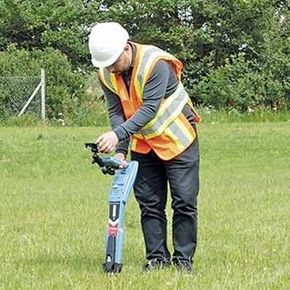
We have undertaken Underground Service surveys from QL A to C based on client requirements nationally. We undertake BYDA and deploy experienced certified locators and a variety of geophysical, electromagnetic, and high-frequency induction techniques to search for known and unknown utilities and structures hidden underground. Our surveyors record the position and depth with high-accuracy survey equipment and thereafter we would tie those into existing controls at the site.
Mining Industry Surveys
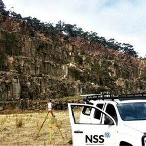
NSS personnel are experienced working at hazardous sites. We utilize state of the art surveying technology, including UAV and 3D Laser Scanning, to obtain required information in a cost-effective manner while mitigating risks associated with data capture in this environment.
Some of the services that NSS provides to the Mining sector include but are not limited to: Site planning
• Survey control network set up
• Monitoring surveys
• Volume surveys
• Compliance audit surveys
• Exploration set out & location surveys
• Detail surveys
• Deformation monitoring surveys
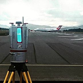
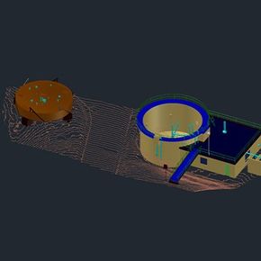
3D Laser Scanning
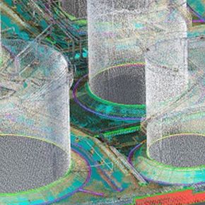
NSS has deep rooted expertise in 3D laser scanning. We have implemented over 200 projects across Australia pertaining to this area of expertise. A 3D scanner provides rapid capture of objects and records 3D coordinates of their location as a series of points (3D point cloud)
Some of the key benefits include:
- Higher level of accuracy than manual methods,
- More comprehensive data reducing the likelihood of repeat site visits
- Cost effective for large scale capture of detailed information
- Higher level of safety for surveying of hazardous, hard to reach/ unhealthy areas
Our instruments can produce 1,000,000 points per second and has a point spacing of <1mm. Observed structures can be modelled in 3D for effective Lifecycle Management, with As-built models superimposed over design models to identify possible friction between new and existing infrastructure, undertake deviation analysis and determining volume
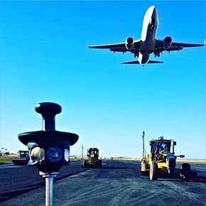
Aerial Photography & Mapping (UAV and airplane)

NSS was one of the first companies in Australia to start using unmanned aerial photography (UAV) or drones for capturing images for surveying way back in 2011 when it became commercially available in Australia. Since then, we have upgraded our technology continually to keep abreast of the times.
Some of the key benefits of UAV include:
• Safe and efficient method of capturing large areas of survey data (including hard to reach/unhealthy areas),
• Faster tool to collect data (no need for using aerial lifts/ladders etc.),
• No delays from interfering with ground work
• Using a high-quality camera with drones it is possible to get the high-quality images from any angle
• Cost-effective option (allowing for rapid, multiple location inspections)
• Allows for making comparisons of before and after shots of one’s workmanship
We have recently ventured into aerial imagery using manned aircraft.
Engineering Surveys
With over two decades of experience in the field, and using cutting edge survey equipment, NSS provides tailor made surveying solutions to the engineering and construction sector clients.
Some of the services that NSS provides in this field include but are not limited to:
• Construction setout
• As constructed surveys
• Road alignment design
• Road formation
• Site & route planning
• Conformance surveys
• Structural surveys
• Relic surveys
• Service setout
• Topographic surveys
• Volume surveys
• Deformation surveys
• Dimensional Control
• Monitoring surveys
• Industrial measurement
Machine Control/Site Guidance Services
Machine Control (MC) involves integration of positioning tools into construction machinery. NSS has a long history of using this technology
The main benefits of incorporating this include productivity gains up to 100% and cost reduction. This is due to higher level of accuracy through reduction in rework, and material savings and reduced use of on the ground survey and earth works personnel for set out and grade checking resulting in a safer solution.
MC can be customized to fit just about any earthworks operation. Machine applications include graders, excavators, bulldozers, compactors, pavers, boring machines, scrappers, trimmers, drum rollers
NSS provides contractors in setting up a site with machine control and machine guidance services including:
• Site calibration
• Support
Uploading designs ready for construction of features including roads, pipelines, dams
BIM
Building information modelling (BIM) includes the process of collecting and creating a digital as-conditions representation of the built environment. These data sets can be used to support Building Information Models that can be used to interpret the data and make strategic decisions.
BIM data, for example, can be used to illustrate the entire lifecycle of a structure. It details the design to demolition where a user can visualize space and objects to minimize error throughout the duration of a project.
The adoption of 3D Laser Scanning within architectural work flows has led to an ever-increasing need for an efficient method of transforming highly detailed 3D Laser Scan survey into documented models, suitable for implementation in BIM work flows.
NSS understands the complexities in the successful execution of developing as-conditions 3D model deliverables which integrate tightly with the work flows. NSS and it partners have developed robust in-house methods to ensure fully client compliant deliverables such as those for Revit, while consulting with the project owner to create a level of detail in the 3D model that is tailor made for the purpose.
A list of our current BIM related services are listed below:
• 2D to BIM conversion service
• 2D CAD drawings taken from the BIM model
• 3D scan of the as-built environment.
• Revit model development
• 2D floor plans and elevations
• Delivery of reality capture meshes
• 3D BIM of the completed as-built site with level of detail required, and as per file format desired
• Fly through and animations
• Delivery of point cloud formats, including Recap, POD and PTS amongst others.
Cloud Solution and Support

NSS provides tailor made cloud solutions and support for clients requiring 3D laser scanning and aerial surveys at multiple locations within the country and abroad